UH’s Use of Impact Modeling Helps to Shape More Resilient Island Communities
For coastal communities around the world, sea level rise (SLR) is one of the more threatening aspects of climate change. Islands, by definition consisting of limited land and water resources, are especially at risk because SLR causes erosion and flooding of the land, salt intrusion of low-lying aquifers, groundwater inundation that forms new wetlands, high wave damage and seawater blockage of drainage infrastructure, and more. In the School of Ocean and Earth Science and Technology’s (SOEST) Department of Geology and Geophysics at the University of Hawai‘i at Mānoa (UH Mānoa), the Coastal Geology Group (CGG) models the future of these problems in Hawai‘i and the Marshall Islands.

Dr. Tiffany Anderson, who received her BA in mathematics from the University of Hawai‘i at Hilo, and her PhD in geophysics at UH Mānoa, works with a small corps of graduate students, technicians and undergraduates on these problems. “The goal of our research is to provide federal, state, and county agencies with actionable model projections of the future impacts of these hazards. Specifically, we modeled SLR impacts for the Hawai‘i Climate Change Mitigation & Adaptation Commission,” said Anderson. The Commission published the model results in the Sea Level Rise Vulnerability & Adaptation Report which was released in December of 2017.
Anderson’s work has focused on developing probabilistic projections of future coastal erosion hazard zones, and modeling seasonal wave run-up on all shores of the islands. Because of the diverse wave climate and reef shapes around Hawai‘i, each beach behaves differently. Anderson prioritizes capturing these local characteristics in the models, to provide meaningful hazard projections on a local scale; impacts which vary greatly from place to place. To obtain the large computing power needed to run the wave model on these small scales, she used the University of Hawai‘i’s High Performance Computing Cluster located on the UH Mānoa campus. Erosion and flood hazards are modeled for the islands of Maui, Kaua‘i, and O‘ahu under 16, 32, 60, and 98 centimeters of sea level rise. Groundwater inundation and hydrostatic flooding are modeled for all of the main islands. These levels of SLR, according to scientific consensus, are expected to occur within a decade or so and continue throughout the century.
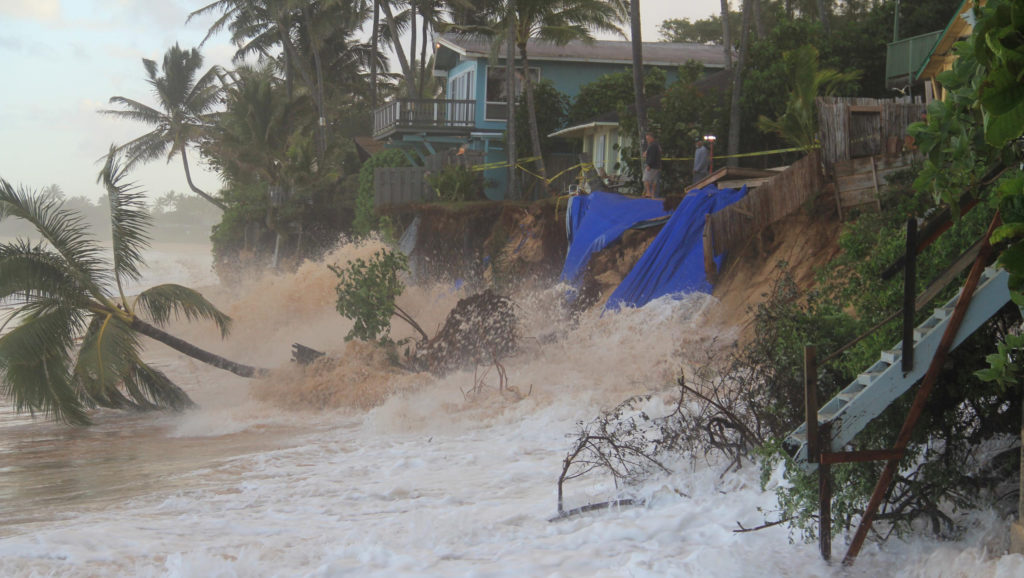
Modeling results indicate that coastal erosion rates, on average, will likely double within roughly the next 30 to 50 years. As shorelines retreat, the beach gets squeezed between the ocean and existing homes and roads. Construction of seawalls to protect upland development causes massive beach loss, a problem that will accelerate in coming years if coastal hardening continues as the management option of choice.
Results of seasonal wave modeling indicate that higher sea levels will cause annual flooding over large land areas. This also means that areas impacted by present-day infrequent wave flooding will experience floods more frequently as water levels rise over Hawai‘i’s reefs.
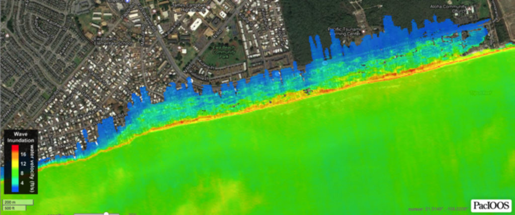
“Currently, many reefs act as buffers to incoming wave energy,” said Anderson. “As sea levels increase over the reefs, more wave energy has access to the shore causing erosion and flooding, especially during high tides.”

Shellie Habel, a PhD candidate in the Department of Geology and Geophysics, is working on identifying the physical characteristics and timing of groundwater inundation that will be driven by SLR. Groundwater inundation occurs when the water table is lifted by SLR and breaks the ground surface creating a wetland. She has developed a three-dimensional model that combines ground elevation, groundwater location, monitoring data, estimates of tidal influence, and numerical groundwater-flow modeling to simulate future flood scenarios due to SLR in the urban core between Diamond Head and Pearl Harbor on O‘ahu.
“This flooding will threaten over $5 billion of taxable real estate; flood nearly 30 miles of roadway; and impact pedestrians, commercial and recreation activities, tourism, transportation and infrastructure,” says Habel. “The flooding will occur regardless of seawall construction, and thus will require innovative planning and intensive engineering efforts to accommodate standing water in the streets.”
Habel has found that the water table is close to the ground surface—within two feet at high tide—in many places. This narrow unsaturated space means that groundwater inundation will become a serious concern well before the end of the century. When it rains and infiltration fills this space, it is a problem already.
Anderson and Habel work closely with Matt Barbee, geospatial analyst with the CGG, and with students Kristian MacDonald, Kammie Tavares and Haunani Kane. “We strive to train local students on the issues associated with SLR so that they can graduate and take their place among the scientific, planning and resource management community in Hawai‘i. These young researchers are keen to serve the people of Hawai‘i and assist with the development of adaptation plans to manage these problems as they worsen in the future, said Dr. Chip Fletcher, associate dean of SOEST, professor of geology and geophysics, and supervisor to members of the CGG. “Sea level rise is a very serious issue for Hawai‘i. It threatens the very existence of our low-lying communities. But I am optimistic that with focused, scientifically informed decision-making, our communities can become vibrant models of resilience for future generations.”