UH Sheds New Light on Hawai‘i’s Groundwater Flow
THE RECENT CONTAMINATION of the Red Hill Shaft well due to leaked jet fuel from the U.S. Navy`’s Red Hill Bulk Fuel Storage Facility on the Island of O‘ahu severely impacted the daily lives of the families, schools, businesses and communities reliant on this major Honolulu aquifer. Although extensive mitigation efforts are still underway at the World War II-era underground facility that holds more than 100 million gallons of fuel just over 100 feet from the aquifer, O‘ahu residents were fortunate to be mostly spared from a potentially devastating water crisis.
“The spill at Red Hill resulted in a renewed appreciation by residents of how important the availability of a safe drinking water source is to an island that is located 2,390 miles from the closest continent,” said Don Thomas, senior researcher and co-founder of the Hawai‘i Groundwater & Geothermal Research Center (HGGRC) at the University of Hawai‘i at Mānoa (UH Mānoa). “Of equal importance, the event forced Hawai‘i’s policy-makers and regulatory agencies to recognize that managing and protecting the quality and the sustainability of the state’s groundwater resources is far more complex and difficult than previously understood.”
According to Thomas, a geochemist who represents the University of Hawai‘i (UH) on a panel of experts formed by the regulatory agencies to oversee the U.S. Navy’s work, a significant disconnect in the situation at Red Hill has been a standing conflict between the groundwater flow model developed by the U.S. Navy’s contractors and an independent evaluation by a team of experts assisting the regulatory agencies that used a broad range of updated groundwater data, including chemistry, temperature and water levels. The U.S. Navy based their conclusions on a groundwater flow model that was developed more than eight decades ago.
The Traditional Model
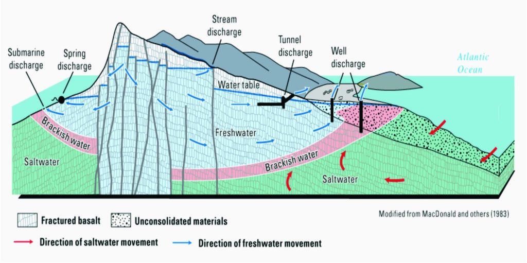
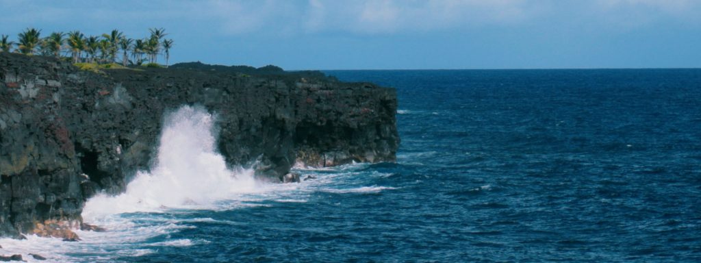
The traditional model was a monumental body of work developed by noted geologists Herald Stearns, Gordon Macdonald, Chester Wentworth and Knute Vaksvik that the Territory of Hawai‘i published as a set of reports on the geology and groundwater resources of each of the main islands. It was based on the measurements and observations of many exploratory and production wells, and describes how rainfall infiltrates the ground and recharges fresh water aquifers that tend to accumulate within ocean islands. Over time, that fresh water recharge migrates toward the shoreline where it is discharged through coastal springs and near-shore submarine groundwater discharge. In regions of higher rainfall, more fresh water accumulates and can displace salt water downward to form a progressively thicker “lens” of fresh water saturated rocks that rest atop salt water saturated rocks below. It served as a benchmark on how Hawai‘i’s groundwater is stored inside the island and flows to the ocean. (See https://scholarspace.manoa.hawaii.edu/handle/10125/50758.)
However, as decades have passed, new techniques and more recent investigations have gathered an increasing body of data that indicate the traditional model does not tell the entire story. Prior to his retirement from UH Mānoa in the mid-1970s, Macdonald explained in a presentation that their model was still incomplete. According to measurements, there was more water infiltrating the islands than they could find being discharged along the shoreline. Something was clearly missing from their equation since input had to balance output. Either their estimates of the volume of groundwater recharge were incorrect, or their method of estimating shoreline discharge was flawed.
Evidence Toward a New Model
Interestingly, one of the first research projects that cast doubt on the traditional model was one that was led by Macdonald himself — the drilling of a deep research borehole in Lower Puna, on Hawai‘i Island, to investigate the potential for geothermal resources. Because the well extended more than a mile below sea level, the scientific team expected it to produce geothermal fluids derived from seawater, but they were surprised to find that the salt content of the production liquid was equivalent to only approximately 10 percent of seawater. Drilled in an unusual geologic environment known as a “dike complex” in the Kīlauea East Rift Zone, the absence of salt water coming from the surrounding ocean was due to dense, impermeable dike rocks.
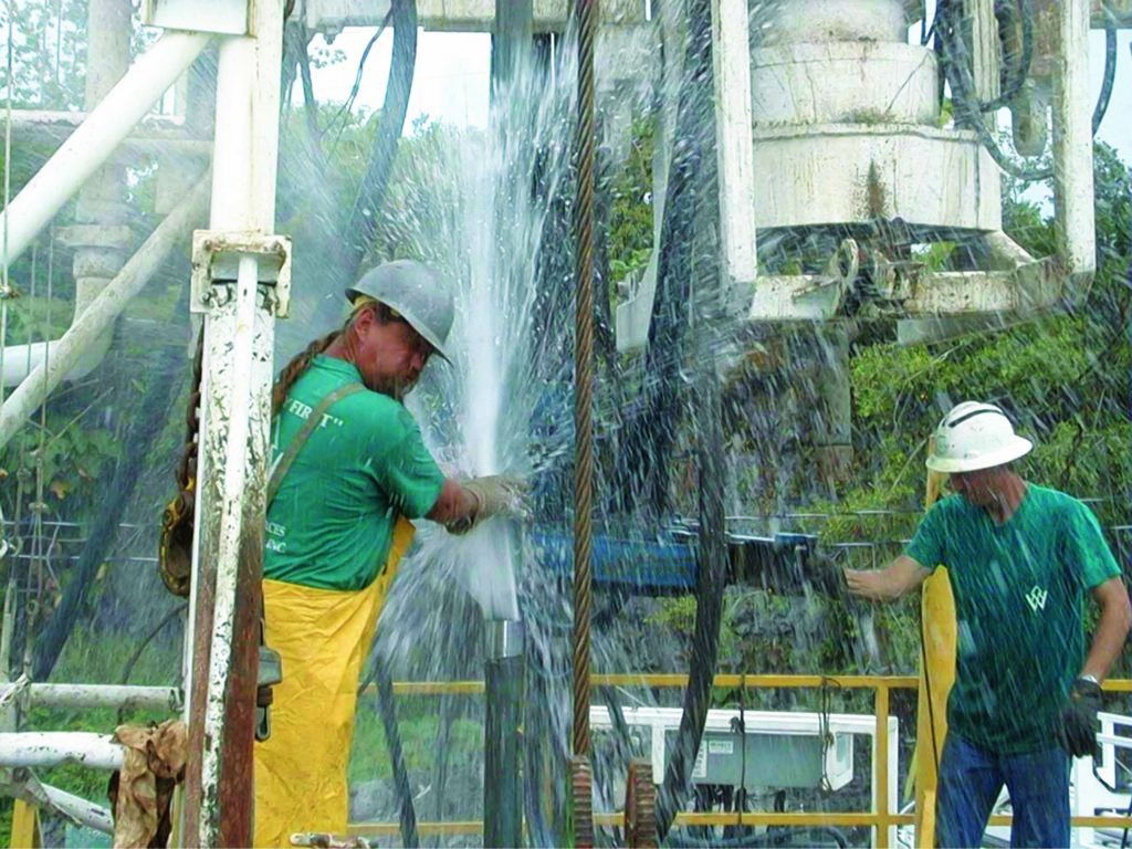
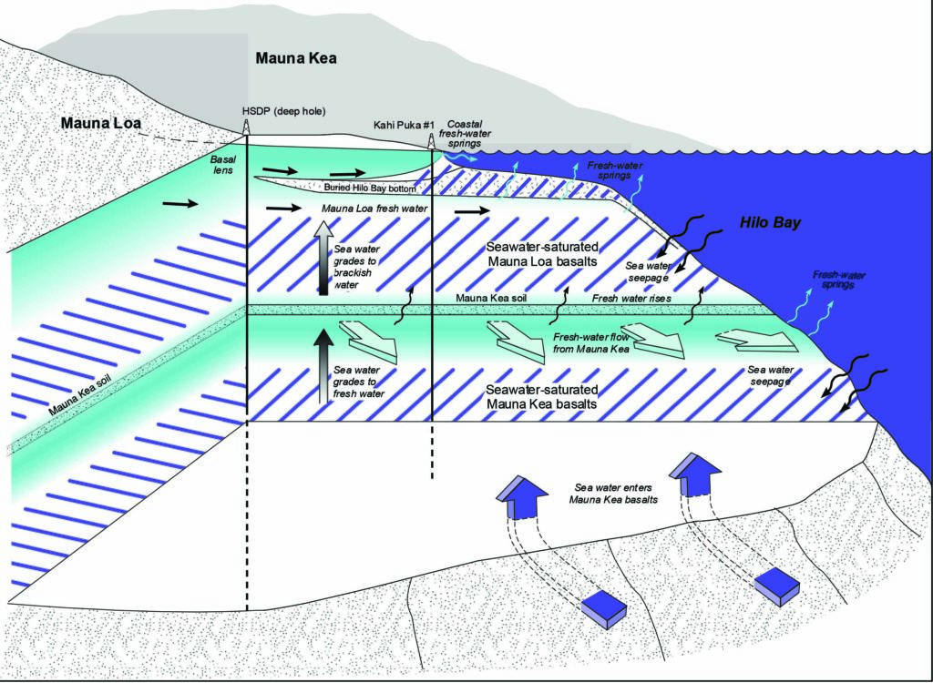
However, another deep well located just north in the town of Hilo provided results that were less simple to explain. The project was sponsored by the National Science Foundation (NSF) and named the Hawai‘i Scientific Drilling Project (HSDP). HSDP studied the evolution of a Hawaiian Hotspot (or mantle-plume) by collecting a nearly continuous sequence of lava flow samples from the ground surface to a depth of 11,540 feet. Researchers expected to drill through a few hundred feet of shallow rocks saturated with fresh water at most, and then into salt water saturated rocks that would continue to the entire depth of the hole. The team drilled through the shallow fresh water lens into salt water at a few hundred feet below the surface, but at about 1,000 feet below sea level, a second fresh water layer was encountered that was determined to have come from rainfall entering the island at an elevation of approximately 7,000 feet above sea level over 2,000 years ago. That water was also unexpectedly artesian and rose to the surface at a rate of more than 2,000 gallons per minute. As drilling continued, layers of fresh water saturated rocks were found down to a depth of more than 10,000 feet below sea level. That water was too old to date using conventional methods, but had a composition that allowed researchers to estimate that it had been in contact with the deep basalts for approximately 100,000 years or longer. There was no rift zone near this location and the findings clearly demonstrated that the conventional model for how groundwater was moving inside the Hawaiian Islands needed an update.
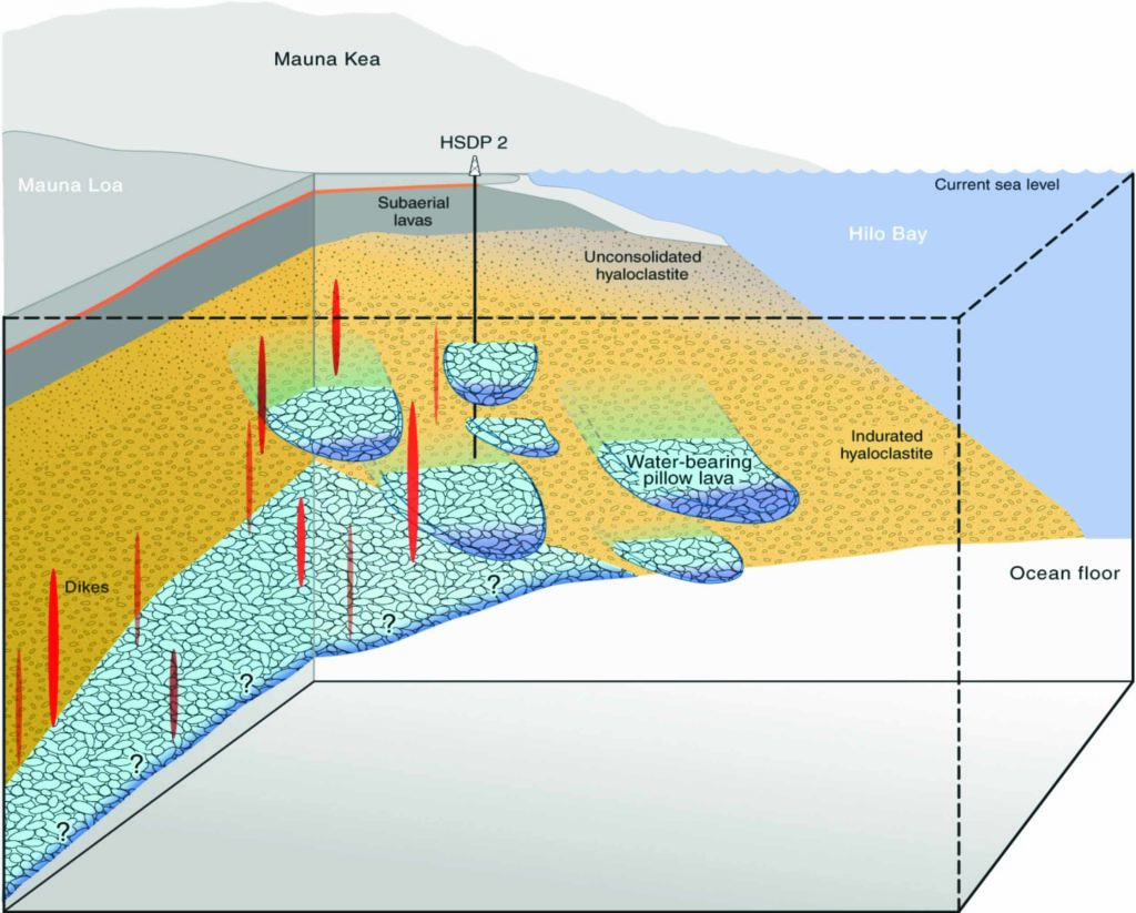
6,500’ below ground surface extending to 10,000’ below ground surface.
“The presence of that deep fresh water also told us something very important: in order for water to get to such great depths into the island, it must displace more dense salt water, but that could only occur if elevation of the fresh water, known as the ‘fresh water head,’ was much higher inside the island than the traditional model had assumed,” said Thomas. “The traditional model argued that, at most, the elevation of the groundwater table would be only 100 to 200 feet above sea level.”
To test the hypothesis that the water table was much higher, UH researchers joined up with geophysicists from the United States Geological Survey to employ geophysical methods to measure the electrical resistivity of the rocks deep inside of the Humu’ula Saddle that extends between Maunakea and Mauna Loa. Those measurements indicated that, over parts of the Saddle, very resistive (dry) rocks extend to depths of only several hundred feet below the surface. Below this to a few hundred feet above sea level, the resistivity is consistent with fresh water saturated rocks, and below that, the resistivity dropped by 95 percent to that of fresh water saturated rocks due to thermal activity.
Two additional wells were drilled higher on the island and the team discovered aquifers that reached an elevation of approximately 4,600 feet above sea level. This elevation of groundwater would provide enough hydrostatic pressure to allow fresh water to the depths first observed in the HSDP well, and is more than sufficient to allow fresh water to displace seawater to the underlying sea floor beneath the island. Tests also indicated that rather than a continuous body of freely mixing groundwater inside the island, different layers of soil and ash form impermeable barriers to the free flow of water and form what are called confined aquifers. In one of the confined aquifers, researchers found that the water pressure below the confining layer was able to send water to an elevation of more than 3,500 feet above the aquifer depth.
Importance of the New Findings
Recently, UH conducted more detailed investigations of the groundwater on the west side of Hawai‘i Island, where water is scarce. That research, funded by ‘Ike Wai, an NSF-funded Established Program to Stimulate Competitive Research (EPSCoR) project, revealed that similar confined aquifers are present on the flanks of Hualālai Volcano, where recent wells have also encountered a similar sequence of fresh — salt — fresh layering. Geophysical surveys conducted offshore showed that those aquifers extend out into the submarine flanks of Hualālai and represent a very large, previously unrecognized reservoir of fresh water. These deep fresh water aquifers have water that is of higher quality than the previously developed basal groundwater system, and which can be accessed at a much lower elevation than wells further inland.
Despite these encouraging discoveries, Thomas cautions that more work needs to be done to understand how the deep fresh water system responds to water withdrawal, and the potential environmental implications of its use. However, these discoveries open up the possibility that wells which pull water from the basal aquifer and consume huge amounts of energy can be shut down, resulting in the restoration of the natural flow of shallow groundwater discharge and the reintroduction of essential nutrients to the near-shore ecosystem.
“Some of these same features, confined saturated layers with groundwater elevations well above where they are expected to be, can be observed in the data produced by the U.S. Navy contractors’ work in the vicinity of the Red Hill facility,” said Thomas. “That clearly indicates that we cannot just assume that groundwater will follow the paths prescribed by our traditional model for Hawai‘i’s groundwater flow.”
In response, UH has requested funding from the Office of Naval Research to conduct extensive geophysical work, as well as a detailed analysis of the geology, and groundwater chemistry, to develop a conceptual model for groundwater flow at Red Hill that is consistent with both large-scale and small-scale geologic features. Features that researchers now understand have a much greater influence over groundwater and contaminant transport than is possible with the existing U.S. Navy model.
Once we have completed work related to the Red Hill fuel contamination, it is our intention to expand our efforts island-wide to better understand O‘ahu’s groundwater resource, then extend these studies to the other islands. We hope that a better understanding of our groundwater will lead to better protection and management of these irreplaceable resources.
– Don Thomas